Aleutian Islands (Alaska)
Cruise Port schedule, live map, terminals, news
Port Aleutian Islands cruise ship schedule shows timetable calendars of all arrival and departure dates by month. The port's schedule lists all ships (in links) with cruises going to or leaving from Aleutian Islands, Alaska. To see the full itineraries (ports of call dates and arrival / departure times) and their lowest rates – just follow the corresponding ship-link.
| Day | Ship | Arrival | Departure |
|---|---|---|---|
| 4 June, 2025 Wednesday | |||
| 4 June, 2025 Wednesday | |||
| 6 June, 2025 Friday | |||
| 6 June, 2025 Friday | |||
| 12 June, 2025 Thursday | |||
| 12 June, 2025 Thursday | |||
| 15 June, 2025 Sunday | |||
| 15 June, 2025 Sunday |
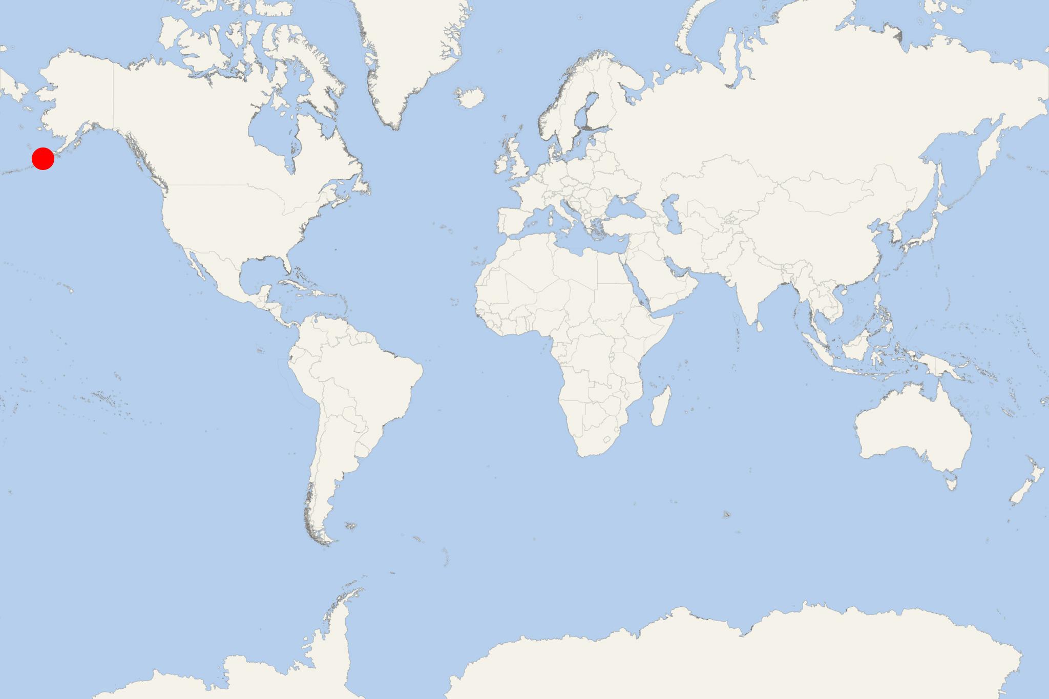
The Aleutian Islands in the Northern Pacific Ocean are a chain/archipelago of 14 large islands plus 55 smaller-sized isles. Some belong to the USA and some to Russia. The group's total land area is 6821 mi2 (17666 km2). It extends approx 1200 mi (1900 km) westward from Alaska toward Kamchatka Russia. They also mark the dividing line between Bering Sea (north) and Pacific Ocean (south).
As a cruise destination, the Aleutians are visited mainly by smaller-sized ships and superyachts from the fleets of ultra-luxury travel brands like Seabourn, Silversea, Hapag-Lloyd, Ponant, Crystal, Windstar, Azamara.
The Aleutian archipelago contains the USA's westernmost territory (Attu Island) and Russia's easternmost territory (Semisopochnoi Island). While nearly all Aleutians are part of Alaska State, at the extreme west Commander Islands are Russian.
The Aleutians' westernmost island is Attu, with Russia's Commander Islands located approx 208 mi (335 km) to the west. Attu is ~1100 mi (1800 km) from mainland Alaska, ~750 mi (1210 km) northeast of Kuril Islands Russia, and ~4800 mi (7700 km) from Washington DC.
The Aleutians are also part of the Pacific Ring of Fire (its northern part), with 57 active volcanoes. Sadly, the Aleutians are best known for the battles there during WW2 (1939-1945). The air-bombing of Dutch Harbor (Amaknak Island, Unalaska) in June 1942 was one of only two attacks on US territories - preceded by the attack on Pearl Harbor (Oahu Island, Hawaii) in December 1941.
The Aleutians comprise of 5 archipelagos, listed next (east to west) and in brackets - the names of their largest islands (also east to west).
- Fox Islands (Umnak, Unalaska, Amaknak, Akutan, Akun, Unimak, Sanak)
- Four Mountains Islands (Amukta, Chagulak, Yunaska, Herbert, Carlisle, Chuginadak, Uliaga, Kagamilislands)
- Andreanof Islands (Gareloi, Tanaga, Kanaga, Adak, Kagalaska, Great Sitkin, Atka, Amlia, Seguam)
- Rat Islands (Kiska, Little Kiska, Segula, Hawadax/Kryssei, Khvostof, Davidof, Little Sitkin, Amchitka, Semisopochnoi)
- Near Islands (Attu, Agattu)
- Bogoslof is formed as a summit of a stratovolcano.
Among the largest Fox Islands (Attu, Unalaska, Umnak, Unimak), the largest one is Unimak (4070 km2 / 1571 mi2), followed by Unalaska (2720 km2 / 1051 mi2).
The Aleutians form a curved island chain similar to Kuril Islands Russia, Japan, and The Philippines. All these arcs are located at the Pacific Plate's edge and experience seismic activity. The Aleutians are located between the tectonic plates of the Pacific Ocean and North America. Their elevation is greatest in the eastern and least in the western islands. Their coastlines are rocky and approaching them is exceedingly dangerous. The land (steep mountains) rises immediately from their coasts, reaching heights of 6200 ft (1900 m).
The plant growing season is 130+ days (early-May through late-September). Due to the strong winds, the Aleutian conifers rarely reach a height of 10 ft (3 m), with many of them being less than 5 ft (1,5 m) tall. Instead of trees, these islands are covered with dense growth of shrubs and herbage (berries, grasses, sedges, low-flowering plants, Aleutian shield fern).
The islands' fauna is represented by large colonies of breeding seabirds and some Asiatic birds. Radioactivity is present after the nuclear weapon testing on Amchitka Island (1971).
Today, most of the Aleutians are protected wilderness areas as part of the Alaska Maritime Wildlife Refuge (total area 4,9 million acres / 20,000 km2, of which the wilderness area is 2,64 million acres / 10700 km2) and the Aleutian Islands Wilderness(total area 1,3 million acres / 5300 km2).
On the less mountainous Aleutian Islands, the economy used to be raising sheep, reindeer, bisons, even some llamas (on Unalaska). The islands' current economy is based primarily on fishing, and the US military presence in the archipelago. As transportation, there are air- and ferry services, plus the Alaska Marine Highway passing through most of the Alaskan islands.
In the "USA top 10" largest Alaskan islands are Kodiak, Prince of Wales, Chichagof, St Lawrence, Admiralty, Nunivak, Unimak, Baranof Island.
Adak Island
Adak Island's largest settlement is the port town Adak (population around 400). Adak is the USA's westernmost and Alaska's southernmost island, with length 34 mi (55 km), width 22 mi (35 km). By total land area (approx 275 mi2 / 711 km2) it is ranked USA's 25th largest island.
In Aleutian, the word adak (adaq) means "father". The island's vegetation is at lower elevations only and mostly tundra (no trees) - low-lying flowering plants, berries, grasses, mosses. The weather is harsh - strong winds (gusts in excess of 120 mph / 190 kph), cold temperatures (20-60 F / -7 to 16 C), extensive fogs, frequent clouds, cyclonic storms and rains (260+ rainy days per year). Island's highest elevation point is Mt Moffett (northwest end) - 3924 ft (1196 m).
In the 18th century, Russian explorers visited for the first time the island but didn't establish permanent settlements. During WW2, the Japanese Imperial Army took control of the Aleutian Islands Attu and Kiska, from where they air-bombed the US base at Dutch Harbor (Amaknak Island, Unalaska). In response, the USA started a military campaign that required the construction of bases to launch operations from the western Aleutian Islands. Adak was the island chosen for building an airfield (today Adak Airport). Flight operations started in September 1942. In May 1943, American soldiers landed on and conquered Attu Island (2300 Japanese and 550 Americans died in the battle). When US soldiers landed on Kiska Island (August 1943), they found that the Japanese were evacuated by their navy, right after the Adak battle. During WW2, Adak was populated by approx 6000 US military personnel.
Adak Town is on Kuluk Bay, located approx 1200 mi (1930 km) southwest of Anchorage AK and approx 450 mi (724 km) west of Dutch Harbor AK. Flight time from Adak to Anchorage is 3+ hours (depending on weather). Adak is on the same latitude as Vancouver Island (BC Canada).
Adak Airport (state-owned, west of Adak Town) is one of the Aleutians' largest and most sophisticated. It was built by the US Navy and used mainly for Naval air transportation. It has two runways with lengths 2,4 km (7800 ft) and 2,3 km (7600 ft). Adak Airport currently serves regularly scheduled flights (by Alaska Airlines) linking to Anchorage AK (Ted Stevens Airport).
Attu Island
Attu Island is the USA's westernmost point. Attu has length 35 mi (56 km) and width 20 mi (30 km). By land area (345 mi2 / 893 km2) it is ranked the USA's 23rd largest island. Attu is uninhabited since 2010 when the Attu Station (USCG Station LORAN) was permanently closed/decommissioned and its personnel (20 people) left the island.
The Aleut people were the island's inhabitants prior to WW2. On June 7, 1942, the Japanese landed on Attu (without opposition) after landing on Kiska Island (June 6th). in response to the invasion, the Alaskan authorities conducted a mandatory evacuation of ~900 Aleuts from the Aleutians. When the Japanese landed, Attu's population (45 Aleuts and 2 Americans) were captured and imprisoned in a camp near Otaru Japan.
In September 1942, the Japanese Attu Island garrison was transferred to Kiska, leaving Attu essentially unoccupied. In October 1942, the Japanese re-established their Attu base (at Holtz Bay) with about 2300 troops (by March 1943). In May 1943 started the US operation to recapture Attu. The following battles resulted in 3929 US casualties (including 1200 with severe cold injuries). At the end of May, the Japanese troops were finally defeated in Massacre Valley (2351 dead) where the Americans built later the "Navy Town". In August 1943, the Japanese forces evacuated Kiska.
Kiska Island
Kiska Island has length 22 mi (35 km), width 1,5-6 mi (2,5-10 km), total land area 107 mi2 (278 km2) and is part of the Aleutians' Wilderness Park, meaning special permissions to visit are required.
Kiska was discovered in 1741 by the Russian explorer Vitus Bering (1681-1741). Starting 1775, the island (along with mainland Alaska) became one of Imperial Russia's fur trading outposts. In 1867, the USA negotiated the purchase of Alaska from the Russian Empire, with Kiska included in the deal.
Kiska has an active volcano (on the northern end). In January 1962 there was an explosive eruption with lava extrusion. A second eruption with lava flow was reported in March 1964.
During WW2 ((on June 6, 1942) the Japanese military forces landed at Kiska, and on June 7th captured Attu Island. During winter 1942-1943, they reinforced and fortified both islands. The US Navy started operations to cut Kiska Island's supply. In October 1942, US forces bombed the island 5 times. Following winter 1942-1943, Attu was liberated and Kiska bombed once more before a larger US force (including 95 warships and 168 aircraft) defeated the Japanese garrison on Kiska in August 1943. However, after the loss of Attu Island (in May) and the impending arrival of the Allied forces, in July the Japanese removed all their troops without being noticed.
Atka Island
Atka Island has length 65 mi (105 km), width 2-20 mi (3-30 km) and total area approx 405 mi2 (1048 km2), ranking it USA's 22nd largest island. In its northeastern part is located the Korovin Volcano (height 5030 ft / 1533 m).
Atka's westernmost point is Cape Kigun, approx 3,4 mi (5,5 km) from Oglodak Island. Port Atka AK is on the eastern coast and has population around 100.
Unga Island
Unga Island is the largest of Shumagin Islands (just off mainland Alaska/Alaskan Peninsula). The island has total area approx 171 mi2 (442 km2), ranking it the USA's 35th largest.
Unga is currently uninhabited. It was previously named Grekodelarovskoe Ostrov - after Evstratii Ivanovich Delarov (1740-1806) - Greece-born skipper who served the Russian-American Company (fur trading company) in Alaska, which was then called Russian America.
In the 19th century, Unga Island's economy was based on mining and cod fishing. With the decline of these industries, its population departed, leaving a ghost town in its place. Puffins, kittiwakes, cormorants, sea otters and peregrine falcons are prominent among the cliffs of this picturesque island.
Seguam Island
Seguam Island is uninhabited and mountainous, with total area 80 mi2 (207 km2), length 16 mi (26 km), width 7 mi (11 km), highest elevation point (Pyre Peak) 1054 m (3458 ft). It consists of several composite/conical volcanoes and contains 2 calderas/volcanic craters.
The last (explosive) eruption was reported in 1993 (at Pyre Peak/the western caldera) that produced lava flows.
Chagulak Island
Chagulak Island is round-shaped (diameter 1,9 mi / 3,1 km) and consists of a single cone stratovolcano (height 3747 ft / 1142 m). Chagulak is separated from Amukta Island via a sea channel (width 4,3 mi / 7 km).
Chagulak and Amukta are underwater-linked.
- Cruise Industry

Ultra-luxury superyacht Scenic Eclipse 2 enters final building phase
Scenic Cruises announced that its new ultra-luxury superyacht - Scenic Eclipse 2, is now entering the final phase of build with sea trials/final...
February 15, 2023 - Cruise Industry

Tradewind Voyages launches 2022-2023 program for its Golden Horizon ship
Ahead of the inaugural ex-Harwich England sailing of Golden Horizon on July 1, 2021, the new cruise brand Tradewind Voyages UK launched its 2022-2023...
June 13, 2021 - Cruise Industry

Hurtigruten’s Valentine’s Day cruise promotion
Hurtigruten announced the company's 2nd annual North America “Suites for your Sweet” promo offering an additional 10% off per person with...
February 10, 2021 - Cruise Industry

Aurora Expeditions' new cruises for Sylvia Earle ship in 2022
Aurora Expeditions launched a new lineup of expeditions for 2022. Early-bird bookings receive savings of 25% off. The small-ship cruise company...
January 27, 2021 - Accidents

Alaska state ferry out of service after crew tests positive for Coronavirus
The Alaska state ferry MV Tustumena is now out of service with some passengers and crew in isolation after a crew tested COVID-positive Saturday...
June 8, 2020 - Accidents

Silver Explorer Runs Into Fishing Net
Silversea Expeditions ship Silver Explorer has become entangled in a drifting fishing net which damaged the vessel and forced a drydock for repairs...
June 26, 2019 - Cruise Industry

Crystal Opens Bookings for Endeavor
Adventurous luxury passengers can already book their 2021 expeditions onboard Crystal Endeavor, as reservations opened for the full year of the polar...
March 14, 2019 - Cruise Industry

Crystal Announces Endeavor’s 2021 Deployment
Crystal Expedition Cruises announced the complete 2021 deployment for the luxury expedition yacht Crystal Endeavor. During expedition voyages that...
March 7, 2019 - Cruise Industry

Alaska Ferry Services Threatened by Winter Shutdown
The Alaska Marine Highway System has no scheduled sailings past October 1, 2019, amid funding uncertainty in the budget proposal of Alaska Government...
February 27, 2019 - show more news

 34°F
34°F 
 Mod. breeze